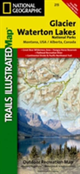
National Geographic Trails Illustrated Map Glacier National Park
16
%
337 Kč 399 Kč
Expedice za 2 až 3 dny
Sleva až 70% u třetiny knih
The Waterton Lakes NP section of the map includes Waterton Park, Upper and Middle Waterton Lakes, The Border Ranges, Akamina Kishinena Provincial Park, Blood Timber Reserve, and more. The Glacier National Park part covers the entire national park area, with detailed trails, and topographic information. Includes the Lewis and Clark Range, Many Glacier, Lake McDonald, Great Bear Wilderness, Flathead National Forest, Columbia Falls, Horse Reservoir, St. Mary Lake, and much more. UTM grids for use with your GPS unit are also provided.
| Nakladatel: | National Geographic Maps |
| Rok vydání: | 2013 |
| Jazyk : | Angličtina |
| Vazba: | Sheet map |
| Počet stran: | 1 |
Mohlo by se vám také líbit..
-

Učebnice jazyka C 1.díl 6.v.
Pavel Herout
-

Učebnice jazyka Java 5.v.
Pavel Herout
-

TCP/IP v kostce
Rita Pužmanová
-

Učebnice jazyka C 2.díl
Pavel Herout
-

Informatika pro základní školy 1
Vladimír Němec; Libuše Kovářová
-

Java 8
Herbert Schildt
-

Excel VBA
Martina Králíčková
-

Microsoft Excel 2016 Podrobná uživate...
Jiří Barilla, Květuše Sýkorová, Pavel Simr
-

Typografický manuál
Vladimír Beran
-

PowerShell
Ed Wilson
-

Moderní programování – sbírka úloh k ...
Radek Stavěl
-

Nápadník do informatiky
Martin Pokorný
-

National Geographic Map Europe Execut...
-
National Geographic Trails Illustrate...
-
National Geographic Adventure Travel ...
-
National Geographic Adventure Travel ...


