

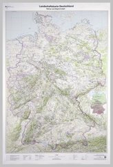
Topographische Karte und Satellitenbildkarte Görlitz

11
%
171 Kč 192 Kč
Sleva až 70% u třetiny knih
Görlitz, Blatt 16, ist Teil eines 30-teiligen Kartenwerks im Maßstab 1:250 000, mit dem Deutschland flächendeckend abdeckt wird.
Die topographische Landkarte Görlitz zeigt die Region mit Cottbus, Bautzen, Hoyerswerda, Zittau, Jelenia Gora, Nationalpark Sächsische Schweiz, Lausitz und Spreewald.
Auf der Rückseite befindet sich eine Satellitenbildkarte (Sentinel-2 aus dem Copernicus Programm) mit dem Bereich entsprechend zur topographischen Karte.
Legende in Deutsch und Englisch.
| Nakladatel: | Bundesamt für Kartographie und Geodäsie |
| Rok vydání: | 2017 |
| Jazyk : | ENG-GER |
| Vazba: | Sheet map |
| Počet stran: | 2 |
Mohlo by se vám také líbit..
-
Střet civilizací
Samuel P. Huntington
-

Pravdivý příběh skupiny Bilderberg
Daniel Estulin
-
Vyhnání
Michaela Peroutková
-

Cesty za oponu času 4
Stanislav Motl
-
Chomutov
Jaroslav Pachner
-

Great Stories in Czech History
Petr Čornej; Magda Veverková
-
Zmizelá Morava Hranice
Jiří J.K. Nebeský
-

Nejkrutější psychopati v dějinách
John Marlowe
-
Dracula
Luboš Y. Koláček
-
Objevovaná Olomouc
Vladimír Gračka
-

Lovci smrti
Jiří Komorous
-

Encyklopedie baltské mytologie
Marta Eva Běťáková
-
Landschaftskarte Deutschland 1 : 750 ...