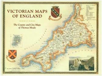
England's Victorian Maps
21
%
759 Kč 961 Kč
Sleva až 70% u třetiny knih
The most beautiful Victorian maps of England's counties and cities by one of Britain's great cartographer's Thomas Moule. The maps are fascinating, decorative and hugely informative of an England in transformation with industrialization and the burgeoning railways. The 60 maps cover the counties of England plus key cities and are accompanied by contemporary descriptions as well as extracts on the counties from the Victorian age.
| Autor: | Moule, Thomas |
| Nakladatel: | Pavilion Books |
| Rok vydání: | 2018 |
| Jazyk : | Angličtina |
| Vazba: | Hardback |
| Počet stran: | 144 |
Mohlo by se vám také líbit..
-

Londonopolis
Latham, Martin
-

Adam Dant's Maps of London and B...
Dant, Adam
-

Ramen
Nilsson, Tove
-

Stitch Stories
Holmes, Cas
-

The Perfect Fit
Bally, Chinelo
-

Berlin Then and Now - Damals und Heute
Gay, Nick
-

Thai Food
Thompson, David
-

Afternoon Tea
Mason, Laura
-

Supra
Tuskadze,Tiko
-

What the Trump?
Stevens, Steven S.
-

The National Trust Book of Crumbles
Mason, Laura
-

A Day in the Life of Woolly Bush - Nu...
Simi, Sarah
-

Capability Brown
Rutherford, Sarah
-

Anna Del Conte on Pasta
Del Conte, Anna
-

Let Me Tell You About Coffee
Townsend, Ben
-

Work - tends to ruin your day
Tate, Cath


